Exploring the Columbus Crossroads
Healing the Divide by Capping and Bridging Freeways: Learning from the Columbus Model
For decades, America’s urban interstates were symbols of speed, progress, and engineering innovation. Freeways created a new pipeline of connectivity between cities that fundamentally changed the way people and goods could travel. This progress, in the name of interconnectedness, came at a dire cost. To ‘pave the way’ for these interstate corridors, communities were destroyed. Neighborhoods were split apart in the name of mobility. In Columbus, Ohio, that story was written with the concrete trenches that were carved through the city in the 1960s. Today, through decades of leadership by MKSK, broken connections are being mended, but this time, by centering on the connectedness of people and their communities.
The Big Idea: Heal the Divide
The I-70/I-71 Innerbelt Corridor is a vital connector through Downtown Columbus. Built in the 1960s, the freeway trench bisected neighborhoods and divided historic communities. As part of its reconstruction, MKSK was commissioned by the Ohio Department of Transportation to reimagine how the freeway could reconnect historic districts, integrating modern principles of urban design and multi-modal transportation. With this technical challenge came a new opportunity to rebuild social and cultural connections, healing the divide and repairing the urban fabric of the city and its beloved neighborhoods. This vision became the “Columbus Crossroads”.

The Columbus Model: enhancing bridge crossings and using various cap designs to reconnect neighborhoods around the Innerbelt (MKSK)
MKSK’s engagement began in 2004, kicking off with an extensive public engagement process to amplify the voices of the communities most impacted by the Innerbelt’s division and reconstruction. It was a critical, challenging, and sensitive role to expand the thinking of ODOT and the engineering team that this was a community-building and restoration project as much as it was freeway widening, and conversely to build trust of the neighborhoods that ODOT could and would make things better as part of the project, rather than worse. Through careful design, thoughtful conversation, and thorough evaluation of alternatives, the team developed a visionary plan that explored innovative technical and social solutions. The plan reimagined more than a dozen bridge crossings—not as replacement utilitarian overpasses—but as opportunities: gateways, plazas, greenspace, and even future retail development to bring people, communities, and business districts back together. In this bold plan, bridges would no longer just cross freeways – they would reconnect neighborhoods, invite people, become valuable public spaces, and begin to mend the gaps in the urban fabric that the freeway had created.
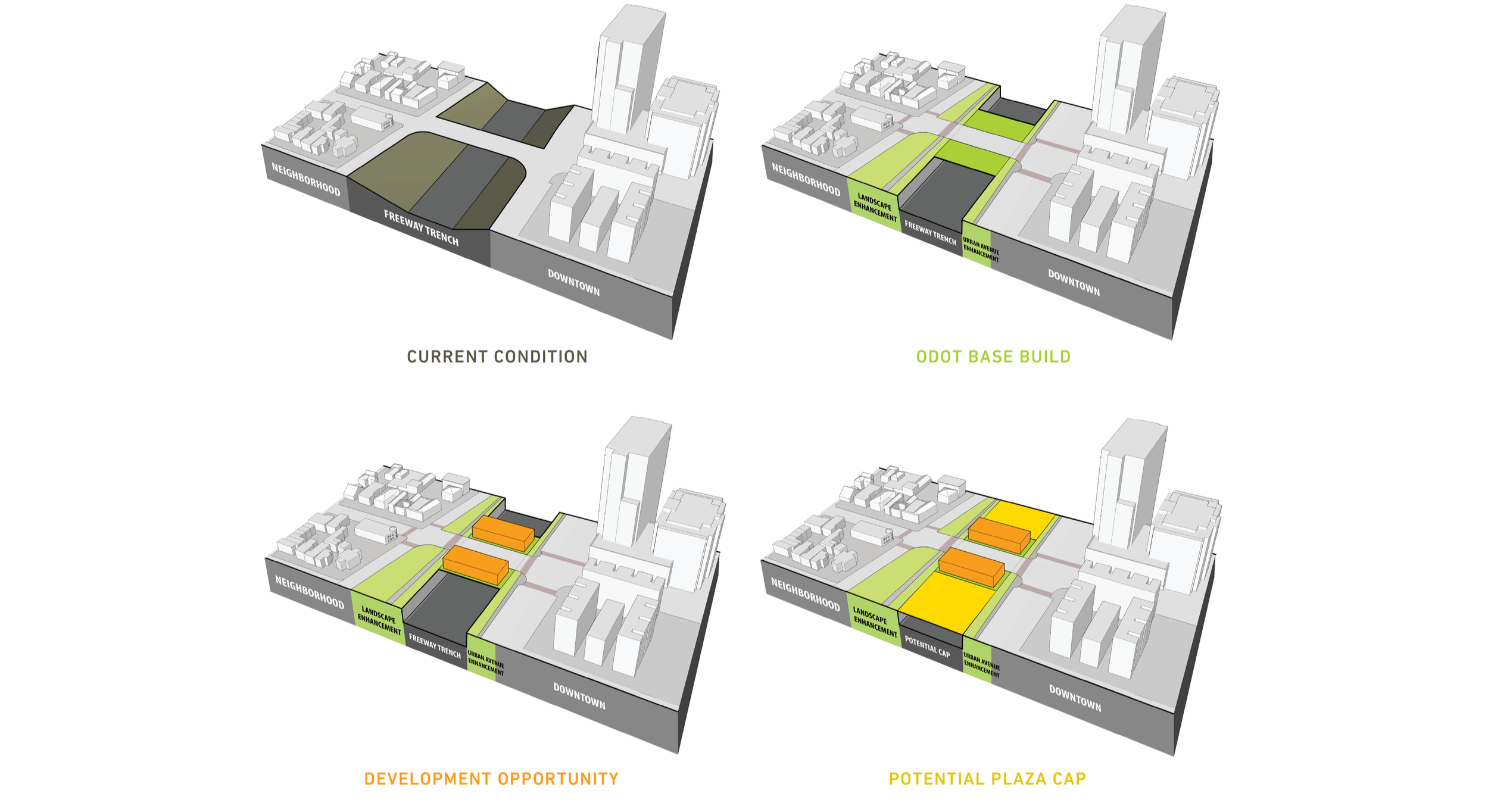
Various cap solutions as part of the Columbus improvement model for its Innerbelt (MKSK)
The Bridge Cap as a Commercial Connector
The inaugural project that kicked off the implementation of the community’s grand vision was the Cap at Union Station – a project that transformed a long-divisive stretch of Interstate 670 into a nationally acclaimed model for freeway caps and stitches. It is one of the first speculative retail projects built over a freeway in the United States.
Opened in 2004 at a cost of $7.8 million, the Cap reconnected downtown Columbus and its Convention Center with the revitalized Short North Arts District by spanning the freeway with bridge structures that support more than 25,000 square feet of retail and restaurant space. The project emerged after neighborhood groups in the adjacent historic district insisted on something more than a conventional replacement of the bridge as part of the freeway’s expansion, advocating for a pedestrian-oriented cap that would restore some of the area’s urban fabric. Community organizations, local developer Jack Lucks, architect David Meleca, city officials, and the Ohio Department of Transportation spent nearly a decade coming to an agreement on the plan and overcoming challenges related to air rights, federal highway regulations, engineering limitations, and financing.

The Cap at Union Station over I-670 (Photo credit: Infinite Impact)
Because no precedent existed for retail construction above a freeway in the US, engineers devised innovative structural solutions, including independently shifting bridge systems, flexible building joints, careful ADA compliance, and integrated utility corridors hidden within the bridge infrastructure. Architecturally, the Cap was designed to evoke the historic Union Depot arcade that once stood nearby, using lightweight materials that echoed Daniel Burnham’s original terra-cotta façade while meeting strict highway safety and load requirements.
The project’s ultimate success demonstrated the economic and civic value of reconnecting neighborhoods severed by mid-century freeway construction. By replacing what critics once called an “engineered gash” with active storefronts, restaurants, sidewalks, and public life, the Cap restored a seamless connection between downtown, the convention center, and the Short North. Continental Real Estate secured tenants willing to pay rents 20 to 30 percent higher than surrounding properties—reflecting the project’s unique location and prestige. Nearly all 25,496 square feet of leasable space was occupied shortly after opening, with restaurants, cafés, specialty shops, and nightlife venues keeping the district active nearly 22 hours a day.
The success of the Cap also proved influential as a national model for future highway cap developments, showing how coordinated planning, civic leadership, and private investment could repair urban divisions and increase the vibrancy of a district while generating sustained economic activity. Though complex and risky (at the time), the project has become a landmark example of infrastructure serving more than transportation needs such as placemaking, walkability, and long-term urban revitalization.
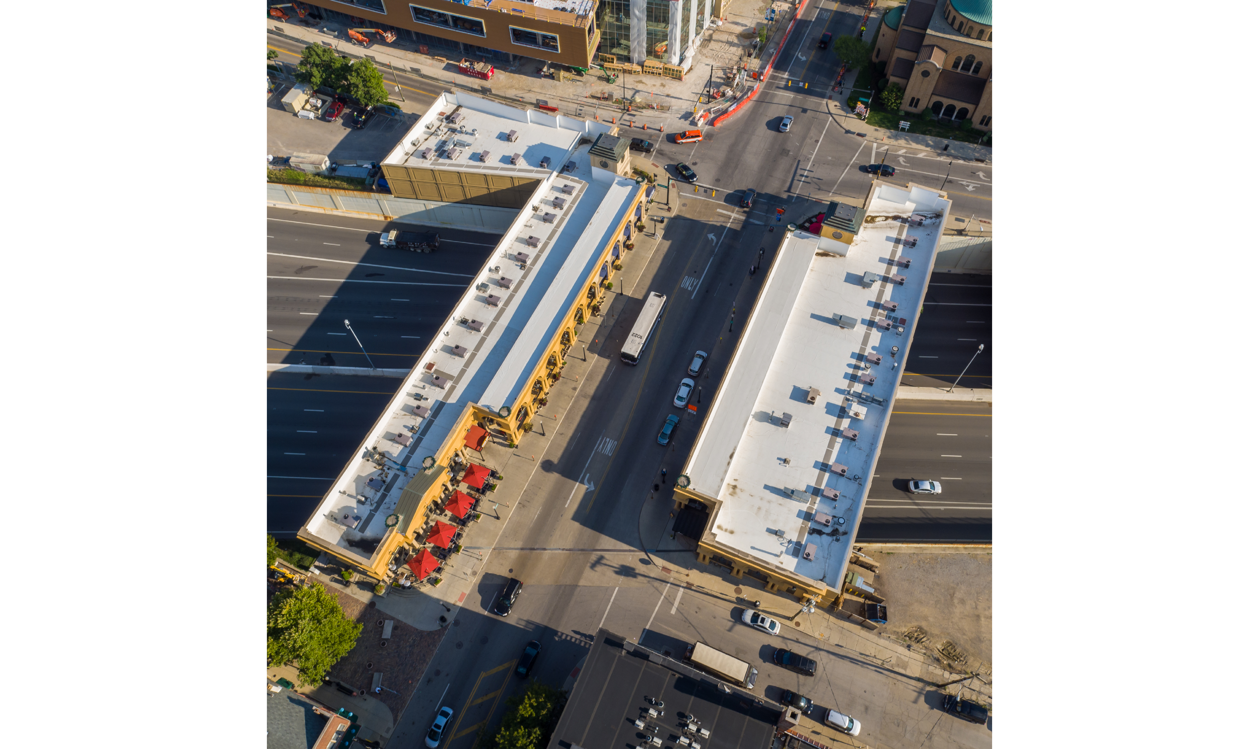
The Cap at Union Station over I-670 (Photo credit: Infinite Impact)
The Bridge Cap as a Cultural Stage
The Long Street Bridge and Cultural Wall is a successful example of how infrastructure can elevate beyond vehicular connections. At first glance, it’s a bridge. Look closer, and it’s a park, a gallery, a memorial, a civic space, and a front porch for the city and adjacent neighborhood.
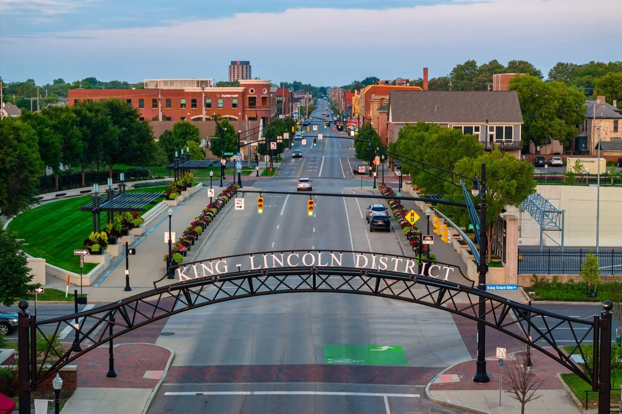
The Long Street Bridge was completed in 2014 as part of the first of more than six phases of the Columbus Crossroads Project, a collaboration between the City of Columbus, the Mid Ohio Regional Planning Commission (MPO), and the Ohio Department of Transportation. The Long Street Bridge connects the Downtown with the historic King-Lincoln District (aka. Bronzeville), once one of the largest, most-vibrant black districts in the US, but devastated by the construction of Interstate 71. As the urban designer for the project, MKSK introduced a green “cap” over the freeway. This landscaped lid turns infrastructure into public space using a complete streets design approach that integrates wide pedestrian ways, bike lanes, and on-street parking together with trees, pergolas, planters, seating, lighting, and landscape along the length of the bridge crossing. The team also incorporated an internally illuminated polycarbonate panel system to replace the standard metal parapet fencing. Suddenly, what was once a terribly uninviting crossing consisting of a narrow sidewalk surrounded by vehicles, noise, spray, exhaust, and chain link fencing became a place for gatherings, events, and everyday life; knitting back together disparate neighborhoods into one cohesive urban fabric.
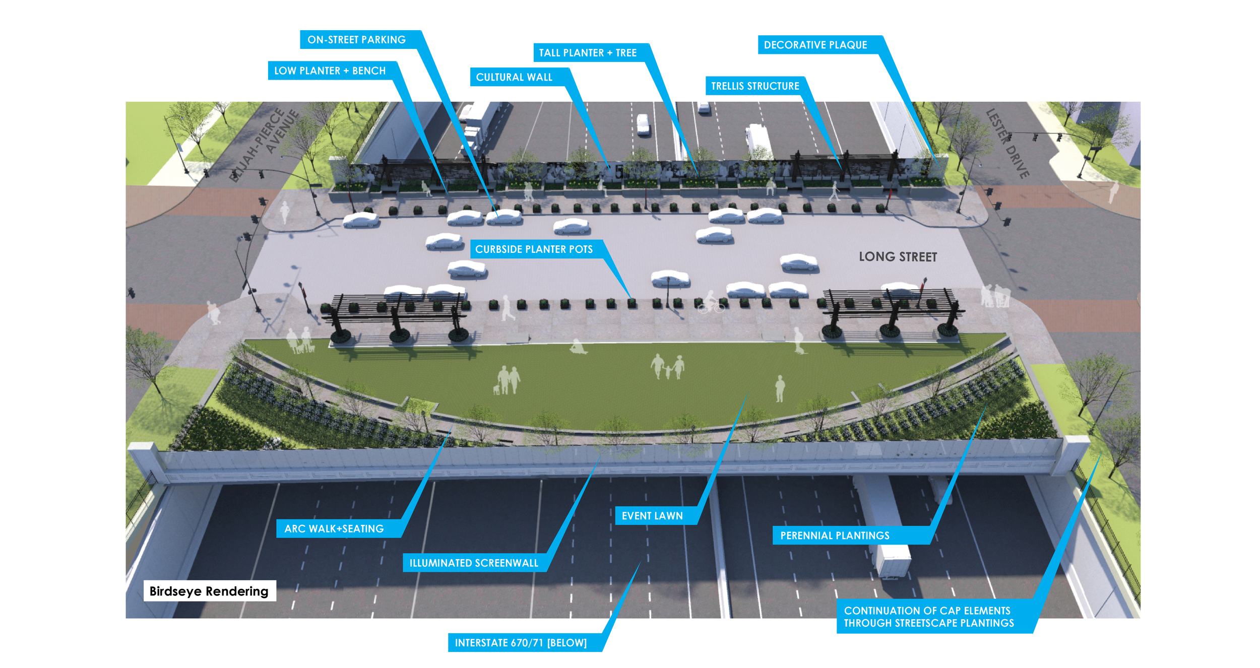
Concept Plan for Long Street Bridge Cap and Cultural Wall (MKSK)
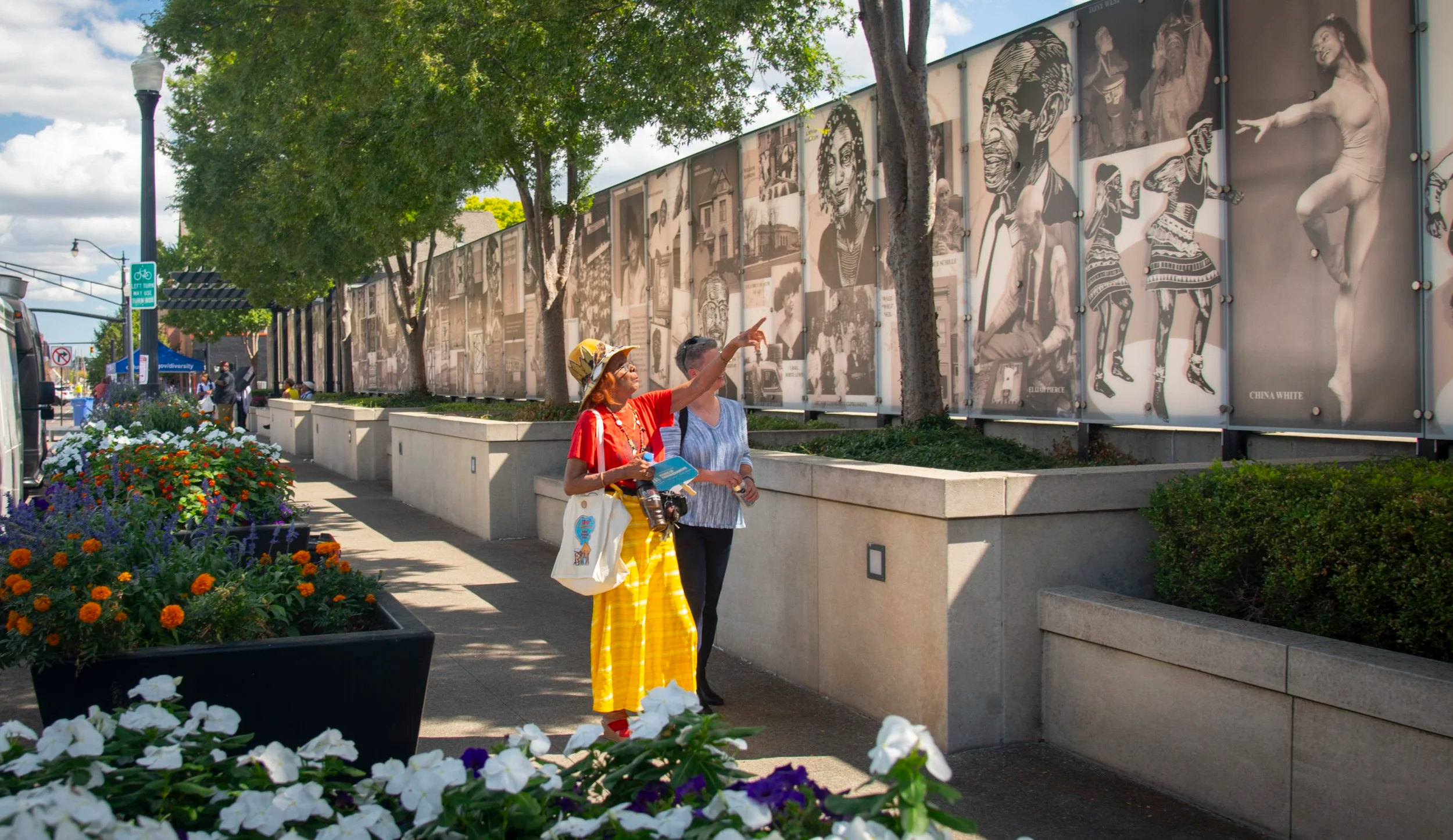
In addition to the significant physical improvements to the bridge infrastructure and the focus on creating an inviting pedestrian space, the Long Street Bridge’s design included a “Cultural Wall” public art piece integrated into the wall panels that celebrates the rich history of the neighborhood and people the freeway bisected. The 240-foot Cultural Wall is part artwork, part storytelling device. Developed with two local artists, the wall celebrates the history, places, people, and leaders of the surrounding neighborhoods, embedding cultural identity and acknowledgment directly into the infrastructure. Where freeways once erased community narratives, the Long Street Cultural Wall showcases their story for all to see with pride and respect.
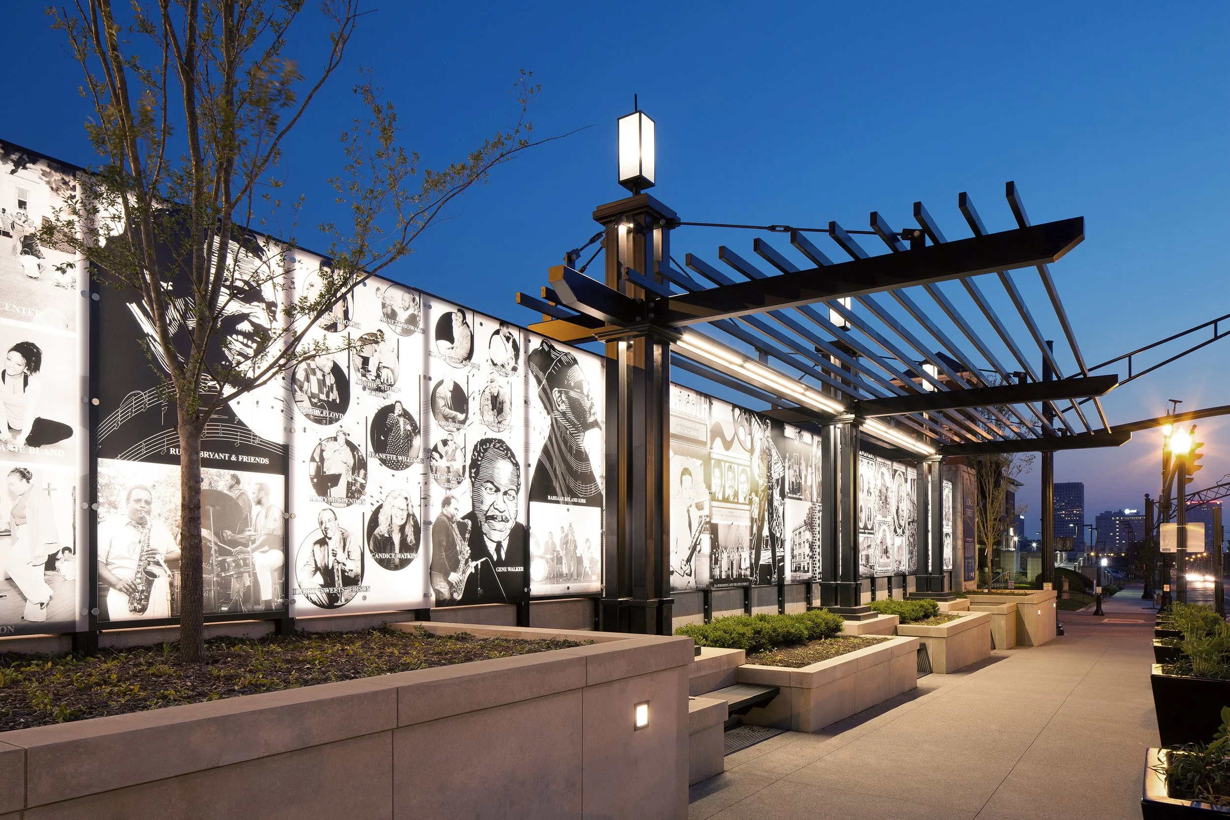
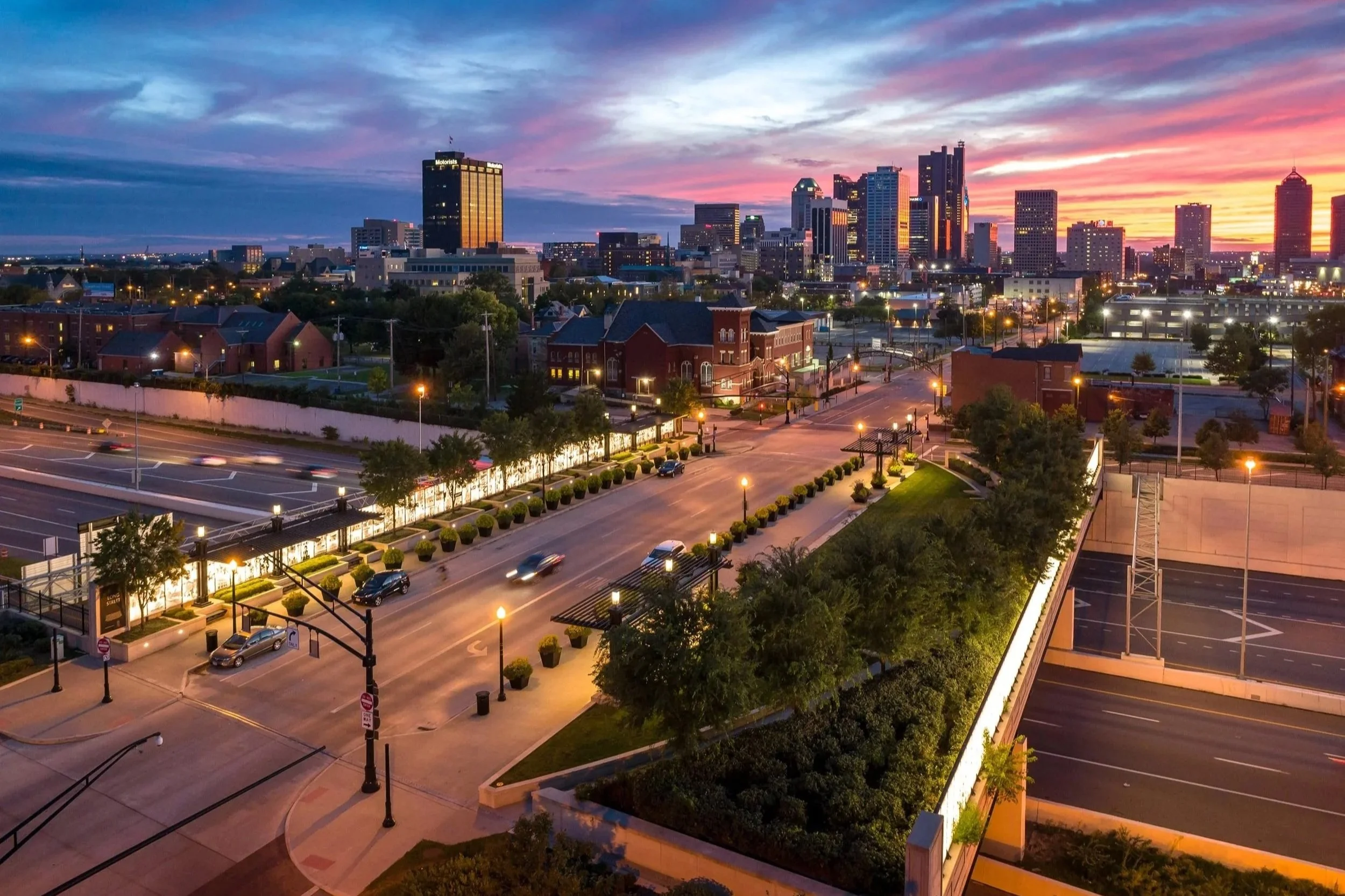

Long Street Bridge Cap and Cultural Wall (left to right: Randall Schieber, Infinite Impact, Nick Fancher)
The Bridge Cap’s Next Iteration
With the High Street Cap and the Long Street Bridge Cap demonstrating what is possible, the next round of projects highlight how that vision is scaling. The Front Street Bridge south of Downtown is nearing completion and is expected to open in the fall, marking another key milestone in reconnecting neighborhoods across the reworked interstates. This bridge cap opening reconnects the Brewery District and sets the stage for the next major phase of bridge cap construction along the I-70/I-71 freeway.
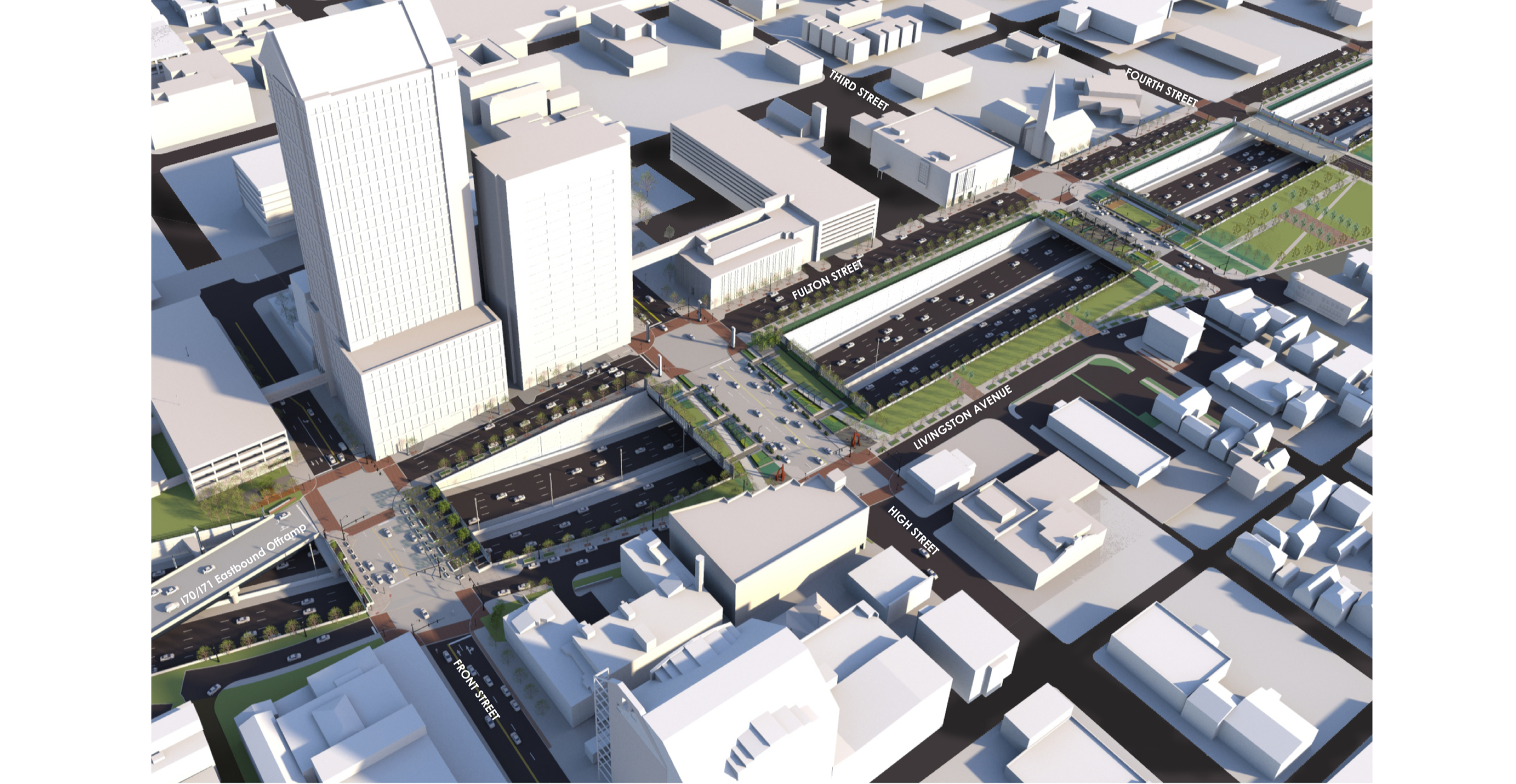
Conceptual Design for Front, S High, and 3rd Street Caps over I-70/71 (currently under construction) (MKSK)
With attention now shifting to the south innerbelt reconstruction, this multi-year effort will result in the addition of three more bridge caps on Front Street, High Street, and 3rd Street. Front Street will serve as a new gateway entry to Downtown, while S High Street with its 60-foot wide green caps reinforces the significance of the city’s most important north-south spine. The 3rd Street bridge cap will go to RFP for development to cross the bridge and line Livingston Avenue, reintroducing the built environment between German Village’s main street and Downtown. These bridge caps will improve connectivity, streetscape design, and pedestrian experience—continuing the broader goal of healing the divide created by the original interstate construction.
Together, these efforts highlight the foundation of the Columbus Model: this isn’t a single megaproject, but a coordinated, incremental transformation. Each bridge re-envisioned, each corridor rebuilt, adds another stitch that brings the once-divided urban fabric back together for all the neighborhoods surrounding downtown.
A New Model for Urban Expressways
Over two decades of planning, development, and implementation have allowed MKSK to become a leader in reimagining and revitalizing disconnected communities across urban freeways. The combined Innerbelt Projects treat each bridge as a unique community connection point, tailored to its surrounding neighborhoods rather than replicating typical vehicular-oriented bridges common of past expressway practices. This approach allocates community enhancement funding throughout the innerbelt in a manner that benefits all neighborhoods rather than focusing all the resources on one, thus turning a linear transportation project into a series of localized placemaking opportunities.
The impact goes beyond aesthetics. Approaching freeway bridge crossings as localized caps provides significant benefits:
Reconnecting neighborhoods divided by infrastructure.
Creating economic development opportunities around new gateways.
Improving safety, accessibility, and comfort for pedestrians and cyclists.
Restoring and reflecting civic pride through culturally meaningful design.
The Big Picture
The transformation of the I-70/I-71 corridor is still unfolding, with multiple phases continuing into the future. The Cap at Union Station has mended a significant disconnect between Downtown Columbus and the Short North while creating new economic opportunities. Likewise, the Long Street Bridge Cap and Cultural Wall illustrate how a green park cap model can repair past harms inflicted by infrastructural divisions and create a community-anchored place, not just a bridge.
With the Front Street Bridge Cap opening soon and the High Street Bridge Cap beginning construction, the decades-old vision of a transformed and reconnected Downtown Columbus is no longer theoretical. The city is being actively reshaped into a place that better serves communities, pedestrians, cyclists, and vehicles with equal respect and opportunity for mobility and connection.
In an era when cities across the U.S. are grappling with the legacy of mid-century infrastructure, MKSK’s work and the Columbus Model offers a compelling blueprint: cap the freeway, yes—but more importantly, reconnect the city, and its communities.
“The Columbus Innerbelt reconstruction project (aka ‘Columbus Crossroads’/ ‘Ramp-Up’) embraced an innovative long-range vision for bridging and capping over highways by centering on re-connecting urban neighborhoods. MKSK looks forward to publishing a companion article later in 2026 to share updates for how the legacy of this work continues to live on as translatable strategies in other cities throughout the country.”
- Chris Hermann, FAICP, Principal
About the Author:
Chris Hermann, FAICP, Principal, has 34 years of professional experience from planning and visioning for comprehensive, downtown, and community strategic plans, to urban design and streetscape/corridor enhancement projects. His engagement on the Columbus Innerbelt reconstruction project spans more than a decade from the I-670 Mitigation and Design Enhancement Plan which set a design vocabulary within the innerbelt, to the I-70/71 South Innerbelt Study and Design Enhancement Manual which included an extensive Public Process of over 100 meetings, and now as part of the design teams for the phased implementation projects. Throughout, Chris has earned the trust of the community on behalf of the ODOT project team. Chris is skilled at helping communities create a unique, compelling vision and translating that vision into strategic steps that transform spaces and communities.